
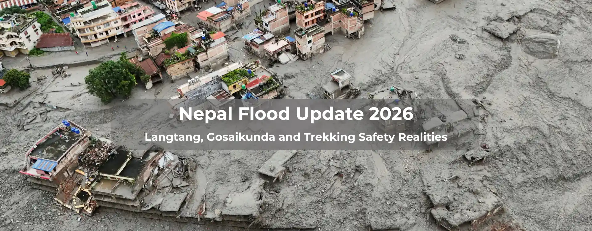
Nepal usually gets described in terms of its high-altitude passes, iconic mountain panoramas, and timeless valley trails. But on the morning of August 26, 2026, conditions in northern Nepal shifted violently within a matter of minutes. A massive Nepal flood that surged down the Bhote Koshi and Trishuli river systems, leaving widespread damage across Rasuwa district and affecting downstream communities across Nuwakot, Dhading, Gorkha, Tanahun, Nawalparasi, and Chitwan.
If you have an upcoming trek planned to Langtang, Gosaikunda, or anywhere along the northern border corridor, here is the honest, grounded breakdown of what actually happened, what the current conditions look like, and how to approach your travel plans without relying on panic or outdated social media reports.
| This page is updated as new information comes in from Nepal Police, NDRRMA, and our own contacts in Rasuwa. Figures below reflect the most recent official bulletins available as of October 1, 2026—treat any casualty or missing-person count as provisional, since it is still moving daily |
What Triggered the Nepal Flood?
Early reports initially mistook the event for an earthquake because the sheer kinetic force of the flood registered as a magnitude 5.2 seismic event. However, scientific assessments from ICIMOD and satellite analysis confirmed the real trigger: a high-altitude slope and glacier collapse high up on the northern flank of Langtang Lirung, near the Nepal-China border.
A massive section of ice, rock, and debris thundered into the upper Lhende Khola. Within minutes, a dense, high-velocity surge carrying boulders and heavy sediment swept into the Bhote Koshi and Trishuli river corridors. Water levels on the Trishuli rose up to nine meters in just thirty minutes, obliterating settlements, hydropower facilities, roads, and bridges downstream.
As of official bulletins on October 1, 2026, the human cost remains severe: over 1,454 confirmed fatalities in Nepal, with roughly 4,718 people still reported missing. Around 21,000+ security personnel, supported by specialized teams from India and China, remain deployed in search-and-rescue operations—including high-risk efforts to clear debris-filled hydropower tunnels around Chilime and Rasuwagadhi. Over 17,000 people have been rescued and are in safety.
Regional Safety & Operational Status After the Flood in Nepal
| Trekking Region / Route | Trail Condition | Road & Access Status | Current Recommendation |
|---|---|---|---|
| Langtang Valley Trek | Upper valley intact (above Syabrubesi) | Pasang Lhamu Highway is severely damaged; the gateway is destroyed and is completely closed. | Postpone your trek or contact your agency on the latest updates. Trekking activities have been suspended until further notice. |
| Gosaikunda Trek | Lakes & high trail intact | Dhunche approach road damaged; high foot traffic from Janai Purnima | Postpone normal departures; await operator & authority updates. Trekking activities have been suspended until further notice. |
| Tamang Heritage Trail | Directly impacted corridor | Roads, bridges, and local communities severely disrupted. | Postpone indefinitely during active recovery. |
| Rasuwagadhi Border | Border post & Miteri Bridge swept away | The Gyirong Port complex was destroyed on the Tibet side. | Closed. Not a viable transit or Kailash pilgrimage route. |
| Everest (Khumbu) Region | Unaffected | Normal aviation & weather considerations apply. | Open & Operational (separate watershed entirely). |
| Annapurna Region | Trails unaffected | Prithvi Highway is experiencing temporary detours at Krishnabhir. | Open & Operational: verify Kathmandu–Pokhara highway status before departure. |
| Manaslu & Tsum Valley | Trails unaffected | Monsoon access road checks required near Trishuli watershed | Open with standard monsoon road verifications. |
The Real Problem: Access Roads & Infrastructure, Not Just Trails
Here is the nuance that most surface-level news reports miss: a trail being intact is not the same thing as a trek being safe or operational.
1. Langtang Valley Trek
The core walking trail that climbs east into the Langtang Valley toward Kyanjin Gompa sits high above the flood line and was largely untouched by the water. Trekkers who were already in the upper valley during the surge were not in direct danger from the river. However, Syabrubesi—the main trailhead town—suffered catastrophic damage to lodges, suspension bridges, electricity, and mobile networks. Furthermore, at least 35 critical bridges along the approach corridor (including structures at Betrawati, Mailung, Haku, and Syafrubesi) have been washed away, along with entire sections of the Pasang Lhamu Highway.
2. Gosaikunda Trek
The sacred alpine lakes and the trail leading up from Dhunche remain structurally safe, as Dhunche sits higher above the riverbed. However, the timing of the flood coincided with the annual Janai Purnima festival on August 28, which drew thousands of Hindu pilgrims into the area. Returning crowds on overland alternative routes (such as the Kathmandu–Sundarijal–Chisapani foot track) have placed immense strain on local infrastructure inside Langtang National Park. Combined with compromised road access, treating Gosaikunda as normally operational right now is unrealistic.
3. Secondary Environmental Risks
Hydrologists and local authorities are actively monitoring the upper catchments above Syabrubesi. Saturated mountainsides remain prone to secondary landslides, and a newly formed high-altitude lake behind the collapse site poses an ongoing risk of secondary outburst floods. Diverting tourist traffic into an active disaster zone also risks draining scarce emergency resources away from local rescue teams.
What About the Rest of Nepal?
It is crucial to keep geographic scale in perspective. A localized disaster in the northern Rasuwa watershed does not mean the entire country is off-limits:
- Everest Region (Khumbu): Sits in an entirely separate river drainage hundreds of kilometers to the east. Flights to Lukla and trails to Everest Base Camp remain completely unaffected by the Rasuwa event.
- Annapurna & Pokhara: Annapurna trails are outside the disaster zone. However, road travelers heading from Kathmandu to Pokhara should note that erosion along the Trishuli River caused a section of the Prithvi Highway at Krishnabhir (Dhading) to collapse on August 30. Traffic is currently being detoured through the Naubise–Palung–Bhainse corridor.
- Downstream Terai & Chitwan: River flooding occurred downstream along the Trishuli and Narayani systems in Nuwakot, Dhading, Gorkha, and Chitwan. While Chitwan safaris remain accessible, riverside itineraries should be verified locally.
Practical Guidance for Upcoming 2026 Travel After Nepal Flood
If you have a trip booked for the autumn 2026 season, here is the honest advice on how to handle it:
- Don’t cancel your entire Nepal trip in a panic: If your itinerary focuses on Everest, Annapurna, or cultural tours across Kathmandu, Pokhara, and Lumbini, your trip is fully viable.
- Set a check-in date with your operator for Rasuwa treks: If you are booked for Langtang or Gosaikunda in October or November, you do not need to make a drastic decision today. Establish a firm check-in date with your registered trekking agency for mid-to-late September. Road crews are actively working, and the situation will be far clearer in a few weeks.
- Verify information through official channels: Avoid self-diagnosing trail safety through social media clips. Cross-reference updates with the Nepal Tourism Board (Hotline: 1234), the Tourist Police (1144), or direct updates from local guides on the ground.
Mountain travel always demands respect for changing local conditions. For now, the most responsible decision for the Rasuwa corridor is to allow emergency services and infrastructure crews the space they need to complete their recovery work.
FAQs for Nepal Flood Update
Is it safe to trek after the recent flash flood in Nepal?
Yes, but safety depends heavily on the specific region and current trail conditions. While certain watersheds (such as parts of the Rasuwa district following flash floods or landslides) may experience temporary closures and infrastructural damage, major trekking corridors like the Everest (Khumbu) and Annapurna regions often remain fully operational. Always check real-time updates from official bodies like the Nepal Tourism Board or your local trekking agency before departing.
Should I cancel my entire Nepal trekking trip if a flood strikes one specific watershed?
No. Nepal’s major trekking hubs lie in completely separate river basins. For instance, a flood in the Trishuli/Bhote Koshi catchment (Rasuwa) has zero direct impact on the Everest region, which operates on an entirely different watershed and relies on flights to Lukla. Unless national travel warnings apply, you can easily pivot your itinerary to unaffected regions.
Is it safe to trek into an area immediately after emergency search-and-rescue operations end?
You should wait until local authorities and independent operators verify trail stability. Saturated slopes pose ongoing risks of secondary landslides, and newly formed debris lakes can threaten lower valleys. Furthermore, entering an active recovery zone too quickly puts extra pressure on local teahouses, food supplies, and rescue personnel who are working to support affected communities


